Monthly Archives: September 2017

Basic Hurricane Maria Incident Map Available

September 27, 2017

The National Alliance for Public Safety GIS (NAPSG) Foundation developed a basic overview of the most relevant available geospatial information for areas impacted by Hurricane Maria, specifically focused on Puerto Rico.

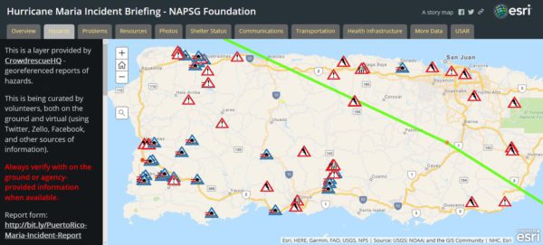
This basic story map provides information on key themes relevant to hurricane response and recovery efforts, including but not limited to:

  • Shelter with status information
  • Demographics
  • Communication infrastructure locations
  • Health facility locations
  • Crowdsourced information on other hazards and problems such as: reported power outages, bridge collapses, etc.
  • Transportation information including live traffic feeds

Check it out and share it around for those in need of basic Hurricane Maria information in Puerto Rico.

Available Now! Hurricane Maria Crowdsourcing Photo App

September 19, 2017 – The National Alliance for Public Safety GIS (NAPSG) Foundation launched a crowdsourcing application to help collect photos and images taken by citizens on the ground during and after Hurricane Maria.

  • If you are on the ground in the impact area (and are safe!), you can contribute your photos to the app very easily using your mobile device.
  • You can also use the app if you are trying to assess the type and extent of damage in the impacted areas to:
    • Prepare for mutual aid response
    • Support situational assessment
    • Aid operational readiness for deployment to the field
    • Other response and recovery functions

Check it out, share it around, and if you are there – contribute!


Available Now! Hurricane Irma Resources & Crowdsourced Photo App

September 6, 2017

NAPSG Foundation has launched a Hurricane Irma GIS Resources group and webpage to provide critical resources for first responders and decision makers supporting Hurricane Irma response and recovery.

The Hurricane Irma GIS Resources group and webpage includes the following:

  • USNG Map Book Downloader
  • USNG 1:25K Map Books for Puerto Rico and the US Virgin Islands – Developed in partnership with Delta State University
  • Hurricane Irma Data, Web Maps, and AppsBest available for public access
  • USNG Resources for Citizen Safety During Irma

NAPSG Foundation is working closely with its partners to address the highest priority requests for GIS-based decision support tools by first responders deployed(ing) in the field for Hurricane Irma.

Additionally, NAPSG Foundation launched a crowdsourcing application to help collect photos taken from the field during and after Hurricane Irma.

  • If you are on the ground in the impacted area, you can contribute your images to the app very easily using your mobile device.
  • You can also use the app if you are trying to assess the type and extent of damage in the impacted areas to:
    • Prepare for mutual aid requests
    • Support situational assessment
    • Aid operational readiness for deployment to the field
    • Other response and recovery functions

Check it out, share it around, and if you are there – contribute!

Our Supporters

Sanborn Geospatial esri here
Dewberry CSX
National Alliance for Public Safety GIS Foundation
5335 Wisconsin Avenue NW, Suite 440, Washington, DC 20015

NAPSG Foundation is a 501(C)(3) charitable non-profit. Taxpayer Identification number: 20-5376630