Monthly Archives: May 2020

S&T Brings Partners Together to InSPIRE Disaster Preparedness and Resilience Innovation

May 19, 2020

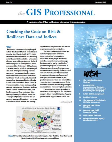
In early March, a series of large tornadoes touched down in Tennessee, killing 25 people and injuring more than 300. Later in the month, tornadoes also struck in Arkansas and several other states. Natural disasters such as these, along with manmade and technological disasters (e.g., oil spills, chemical spills, radiation leaks), can strike any community across the nation resulting in devastation for survivors, businesses, critical infrastructure, and the environment. To help communities prepare for such disasters and rebuild in the aftermath, the Department of Homeland Security (DHS) Science and Technology Directorate (S&T) partnered with the National Alliance for Public Safety GIS (Geospatial Information Services) Foundation (NAPSG) to convene experts from around the country to share best practices and identify practical solutions related to information sharing, geospatial technologies, and leadership.

For the fifth year in a row, DHS S&T has teamed up with NAPSG for the National Geospatial Preparedness Summit, which is now known as the Innovation Summit for Preparedness and Resilience (InSPIRE). The 2019 InSPIRE event was held in Galveston, Texas, in November and brought together public safety practitioners and GIS professionals to build skills in developing and implementing GIS-based decision support tools, develop peer relationships, and validate skills and capabilities through workshops and exercises.

Read the Full Article by DHS Science and Technology Directorate @ https://www.dhs.gov/science-and-technology/news/2020/05/19/snapshot-st-brings-partners-together-inspire

Important: Fundraising Scam Alert

May 19, 2020

Dear NAPSG Community,

Various government agencies have issued warnings about fundraising scams that have been taking advantage of the coronavirus pandemic by contacting individuals by phone/email pretending to be from government or health agencies, hospitals, or insurers. Also, we were notified recently that individuals claiming to be with the “National Alliance for Public Safety” have been contacting individuals for donations.

For these reasons, we’d like to remind you that NAPSG Foundation representatives will never contact you to solicit any funds. If someone asks you for a donation and uses the NAPSG name (or something similar), then it is a scam and should be reported.

Report a Scam

If you believe that you have been a target of a scam, please file an online police report and notify the Federal Trade Commission immediately.

Sincerely,

Peter O’Rourke, Executive Director

ISPRS International Journal of Geo-Information: Call for Papers

May 18, 2020

Call for Papers!

The ISPRS International Journal of Geo-Information is soliciting articles for a Special Issue publication for crisis informatics. While extreme weather events are usually the causes of a crisis, 2020 has become an expensive and deadly year due to another type of crisis, i.e., the COVID-19 pandemic. Whatever the cause of a crisis, though, technologies like cloud computing, location-based services, network science, web applications, and artificial intelligence (AI) are being used for crisis informatics to aid with crisis management and resilience efforts.

Similarly, data obtained from both static and dynamic sources, such as remote sensing, unmanned aerial systems, and social media, enable the development of new approaches to characterize and predict disaster situations at different locations and scales. Human dynamics data in both physical and virtual spaces are big, spatial, temporal, dynamic, and unstructured. The proliferation of data and interactive mapping technologies has also significantly enhanced access to and the utility of spatial decision support systems, helping communities to better prepare for, respond to, and recover from crises and hazards.

While significant advancements have been made in the development of statistical and data-driven models, the data suffers from uncertainties associated with the heterogeneous nature of the data sources – scale, spatial, temporal resolution, etc.

Please consider submitting articles to this Special Issue that advance theories in crisis informatics to aid with crisis/disaster preparedness, mitigation, recovery, and resilience.

Deadline for submissions:  30 April 2021

Launch of the National Pandemic GIS & Informatics Task Force

May 7, 2020

NAPSG Foundation recently joined forces with the National States Geographic Information Council (NSGIC) and the Urban Regional Information Systems Association (URISA) to establish the National Pandemic GIS & Informatics Task Force. The purpose of the task force is to develop a nationwide strategy and plan for unifying data, technology, and information sharing across the local, state, and Federal levels – to increase pandemic preparedness and unity of effort during response and recovery.

The task force is charged with providing thought leadership, expertise, and governance across the emergency management, public health, and technology/GIS communities. To kick-off this effort, the task force is developing a standard Playbook for Integrating GIS in Pandemic Response & Recovery that is based on the timeline of decisions and actions carried out by emergency managers and public health officials prior to, during, and after a pandemic. They are also rapidly developing a portal to curate and share out GIS-related best practices and toolkits among emergency management, public health, and technology/GIS communities for COVID-19.

We encourage our members to keep a pulse on this important initiative. NAPSG will be announcing opportunities to provide comments and feedback on the draft Playbook for Integrating GIS in Pandemic Response & Recovery, contribute best practices from the field, and become a part of ad-hoc working groups in support of the task force mission. Stay tuned for more details!

June 2020 Update: The Strategy & Action Plan for the National Pandemic GIS & Informatics Task Force is now available. Access the action plan here!

February 2021 Update: The COVID-19 Tech & GIS After Action Report & Improvement Plan are now live. To access the AAR, click here!

Cracking the Code on Risk and Resilience Indices and Tools

May 7, 2020

Understanding a community’s risk, resilience, and vulnerability is vital to preparedness, resilience, and disaster management. There are various indices and tools currently available today, but sometimes it is unclear which index and supporting tools are best suited to answer specific questions and actions in the planning stage as well as the timeline of a disaster.  

NAPSG Foundation has joined forces with URISA’s Community Resilience Task Force to form a Risk & Resilience Indices Working Group that addresses these very challenges. The Working Group was launched to understand and develop guidance on the multitude of indices and tools available for risk, resilience, and vulnerability. Our goal is to answer the growing questions such as which index and tools should a planner or emergency management use, when should they be used, and for what purpose.
Learn More About the Initiative
Check out the recent article on this initiative in the March/April 2020 edition of the GIS Professional Journal.

Link to Full Article: https://www.urisa.org/clientuploads/directory/Documents/The%20GIS%20Professional/2020/MarchApril_2020.pdf

Call to Action!

To make this happen, we need your help. We are seeking input from the broader community to document use-cases on the various risk, resilience, and vulnerability indices.

Share your Feedback: https://arcg.is/1fTzSW