Deployment analysis is a planning process fire and emergency services organizations conduct to answer the question: given our current resource constraints (budget), what is the best level and distribution of services we can provide to protect the community we serve? GIS aids this process in three key areas:1. assessing the location, distribution and concentration of potential risks in a community;2. Determining an appropriate level of response capacity for protecting the community against those risks; and 3. Identifying the best locations to position resources for achieve the best possible outcomes when emergencies happen.
CrawlA GIS-supported deployment analysis helps decision makers determine where to move, add, remove, or restructure resources to maximize the potential for achieving desired levels of protection. Information from the risk assessment is used to determine acceptable levels of risk with a clear understanding of protection priorities and levels. |
WalkGeographic data is used to build analysis of coverage area and assess deployment characteristics based on call locations, jurisdictional boundaries, street/road information, speeds, and station locations. This analysis can depict travel time, density of call volumes, frequency of calls, etc. The analysis gives valuable insight for both labor and management to cooperate and make decisions on resource deployment and staffing based on data, not intuition. It gives all parties to the discussion the same basis from which to make these critical decisions for the community. |
RunA mature implementation of this functionality provides web services and mobile web mapping that allows Public Safety personnel to view analysis that is dynamic, current, and can query history. This allows decision makers to intterrogate the data for particular units, time periods, shifts, and response areas. A mature impementation of this capability automates the analysis and is easy to use by non-technical staff. |
| Example: GIS for Fire Service | Example: IAFF Information Resources | Example: Henry County Fire Response Times |
More Resources
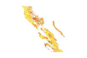 Fire Severity Risk: State and Local Responsibility Areas
Fire Severity Risk in State and Local Responsibility Areas for the San Francisco Bay Region. Data downloaded from the California Department of Forestry and Fire Protection.
Type: Feature Service
Last Modified: November 16, 2023
 1.01 Fire Response Time
This page provides information for the Fire Response Time performance measure.
Type: Hub Page
Last Modified: March 21, 2024
 1.01 ALS Response Time (2012)
Data for the Fire Response Time performance measure.
Type: Feature Service
Last Modified: June 11, 2020
 1.01 ALS Response Time (2014)
Data for the Fire Response Time performance measure.
Type: Feature Service
Last Modified: June 11, 2020
 1.01 ALS Response Time (2015)
Data for the Fire Response Time performance measure.
Type: Feature Service
Last Modified: June 11, 2020
 1.01 ALS Response Time (2018)
Data for the Fire Response Time performance measure.
Type: Feature Service
Last Modified: August 25, 2022
 1.01 ALS Response Time (2013)
Data for the Fire Response Time performance measure.
Type: Feature Service
Last Modified: June 11, 2020
 1.01 ALS Response Time (2017)
Data for the Fire Response Time performance measure.
Type: Feature Service
Last Modified: June 11, 2020
 1.01 ALS Response Time (2016)
Data for the Fire Response Time performance measure.
Type: Feature Service
Last Modified: June 11, 2020
 1.01 ALS Response Time (2022)
Data for the Fire Response Time performance measure.
Type: Feature Service
Last Modified: September 14, 2023


