GIS is very helpful to Public Safety when communicating Evacuation, Sheltering, and Mass Care information to the public. Every event is different and the locations of these things can be dynamic. Depicting this information to the public visually is a very productive use of the technology.
CrawlHelp residents discover hazards that exist in their community and obtain information about evacuation routes, shelters, mass care, and government facilities by creating paper maps that can be used when briefing the community and media. |
WalkProviding an online application of this mapping supports the dissimination of important information 24 hours a day, seven days a week, and typically supplements customer service phone numbers staffed by government and non-government organizations. |
RunExtending the online capability you have created, you can link the data and map symbols to information coming from the field. For example, linking the status of a shelter (open, closed, empty, full, capacity) provides updates to incident managers and the public. |
| Example: Search Evaction at ArcGIS Online | Example: ArcGIS for Local Government | Example: Red Cross Shelters |
More Resources
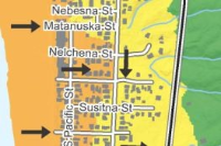
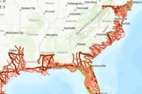 Hurricane Evacuation Routes
This feature layer, utilizing data from Homeland Infrastructure Foundation Level Data, displays the locations of hurricane evacuation routes in the United States. These are designated routes used to direct traffic inland in case of a hurricane threat.
Type: Feature Service
Last Modified: April 1, 2024
 California Active Evacuation Zones
This feature service is an aggregation of multiple California County Evacuation Zone services that are being refreshed every 10 minutes. ***We are not aggregating California County Evacuation Zone Data directly from Zonehaven (https://www.zonehaven.com). The schema used mirrors the Zonehaven schema.
Type: Feature Service
Last Modified: August 1, 2023
 TxDOT Evacuation Routes
TxDOT Major Evacuation Routes maintained by TxDOT Traffic Safety Division (TRF).
Type: Feature Service
Last Modified: March 14, 2024
 Evacuation Routes 2021
This GIS dataset represents major roads that are designated as evacuation routes in the event of an emergency evacuation in Hillsborough County, FL.
Type: Feature Service
Last Modified: June 27, 2023
 CA_EVACUATIONS
This feature service is an aggregation of multiple California County Evacuation Zone services that are being refreshed every 20 minutes. We are NOT receiving California County Evacuation Zone Data from Zonehaven. The schema used mirrors the Zonehaven schema. To find out any information about any County, please contact that County directly. This data is provided as is and is referential only.
Type: Feature Service
Last Modified: February 7, 2024
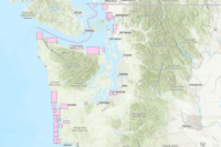 tsu_evacuation_routes
The mission of the Washington Geological Survey (WGS) is to collect, develop, use, distribute, and preserve geologic information to promote the safety, health, and welfare of the citizens, protect the environment, and support the economy of Washington. In order to do this, WGS works with the National Oceanic and Atmospheric Administration (NOAA) and the University of Washington to model the inundation (flooding) of coastal areas from tsunamis. From these models the WGS produces tsunami inundation maps to communicate the hazard identified in these models to emergency management, planners, and the public to prepare for the next event in Washington. The WGS works with the Washington Emergency Management Division and local, county, tribal, and other planners and emergency managers to develop, publish, and distribute pedestrian evacuation maps, and evacuation brochures. These maps and brochures are made for areas that are especially at risk for damaging tsunamis. This feature class contains polygons for areas that have published tsunami inundation maps, and areas for which pedestrian evacuation walk maps, or evacuation brochures were generated. It is also useful for representing where gaps in modeling exist for a given earthquake scenario. The source publications for these data and original model data, where available, are provided as hyperlinks within this feature class.
Type: Feature Service
Last Modified: September 21, 2023
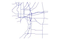
 Mass Evacuation Grids
This is a collection of all four grid systems for use in mass evacuations. The Grid layer is the Regional Public Safety Geodatabase's (RPSG) Public Safety Grid. It was created to be published the Public Safety Mapbook and accompanying web mapping applications which is provided to public safety and emergency management agencies for use in the field for identifying areas for mass notification of evacuation, routing to locations and gathering general situational awareness.
Type: Feature Service
Last Modified: February 10, 2023
 CA_Tsunami_Hazard_Evacuation_NonEvacuation_Areas
Tsunami Hazard Evacuation Map data are intended for local jurisdictional, coastal evacuation planning uses only. The tsunami hazard evacuation area represents an area that could be evacuated during a tsunami event. The location of the tsunami hazard evacuation area was based on the Tsunami Inundation Maps for Emergency Planning (State of California,2020) which represents the tsunami flood area hazard. Guidance from local stakeholders, including emergency managers, first responders, and subject matter experts was used to direct the placement of the final evacuation area in places that would help the public and government safely evacuate during a tsunami event. These data, and the information presented herein, is not a legal document and does not meet disclosure requirements for real estate transactions nor for any other regulatory purpose. Tsunamis are rare events; due to a lack of known occurrences in the historical record, this map and these data include no information about the likelihood of any tsunami affecting any area within a specific time period. Please refer to the following websites for additional information on the construction and/or intended use of the tsunami hazard evacuation area: State of California Geological Survey Tsunami Information: https://www.tsunami.ca.gov/ California Governor’s Office of Emergency Services, Earthquake, Tsunami, and Volcano Program: https://www.caloes.ca.gov/cal-oes-divisions/earthquake-tsunami-volcano-programs/tsunami-about Humboldt County Office of Emergency Services: https://humboldtgov.org/356/Office-of-Emergency-Services/ Redwood Coast Tsunami Work Group tsunami and earthquake information: https://rctwg.humboldt.edu/
Type: Feature Service
Last Modified: April 11, 2022
 DOGAMI Tsunami Evacuation Zones 2013
The intent of this digital data release is to provide seamless, statewide tsunami evacuation zones as shown on Oregon Department of Geology and Mineral Industries (DOGAMI) tsunami evacuation brochures.
Type: Feature Service
Last Modified: January 18, 2024
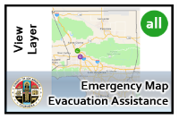 Public Emergency Map Evacuation Assistance View
The location of emergency shelters, evacuation centers, and other services established as a result of an emergency incident.
Type: Feature Service
Last Modified: August 3, 2023


