To aid Incident Management, GIS is most commonly used within the framework of a Common Operational Picture (COP). Whether paper or digital media based, it is a single identical display of operational information of the current Situation Status (what is going on) and Resource Status (position and status of Public Safety resources supporting the incident).
CrawlPerhaps the best start using GIS to support Incident Management is to adopt Standard Operating Procedures. This SOP creates consistency in information delivery of GIS products and services. There are variations of the SOP that will be adopted by your agency to suit your mission, but a good foundation describes the types of maps, data structure, methods to support an incident, data archiving, and transition to other teams. Much of this standard GIS work was established for the wildland fire community, but is equally applicable for any focus within incident management. |
WalkWhile paper mapping is very suitable for incident management support and sometimes preferable in austere IT environments, it is important to begin to collaborate with all parties supporting extended incidents. Using the same SOP foundation, the data should begin to be shared within the sphere of the incident via digital means. Web-based common operational pictures are by far the most common means by which to achieve this. This is also an important moment in developing GIS capability – because it integrates principles of information management and recognizes it as an important part of the process on the same level as people and equipment. Attention in this phase should be paid to integration with internal dynamic systems (CAD, RMS, AVL, staffing) and integration with external partners. |
RunSupport of Incident Management matures when you focus on using mobile devices and field observations. Incorporating mobile into these workflows allows updates to situational awareness to flow into the system as it is happening and allows incident management to communicate the latest updates into a visual layout instantly. This has obvious impact on the speed in which information can be understood and acted upon. It supports incident management at both the strategic and tactical/operational levels by giving context to the hard decisions that experienced Public Safety personel must make. |
| Example: GIS Standard Operating Procedures | Example: Search Common Operational Picture at ArcGIS Online | Example: Florida State Geospatial Assessment Tool |
More Resources
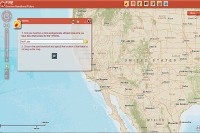
 Common Operating Picture: FEMA DR-4652-NM (ExperienceBuilder)
The Common Operating Picture for DR-4652-NM (NM 2022 Wildfire and Monsoon Season) is a single-stop for response, recovery, and mitigation data across impacted communities. This application allows for users to explore the disaster, and the efforts taking place to restore impacted communities within New Mexico.
Type: Web Experience
Last Modified: October 18, 2023
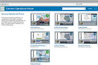
 Common Operational Picture
Common Operational Picture can be used by emergency management personnel to access a collection of role-based applications used when responding to an incident or event.
Type: Web Mapping Application
Last Modified: March 22, 2019
 Common Operating Picture: FEMA DR-4652-NM (Web Experience, Public)
The Common Operating Picture for DR-4652-NM (NM 2022 Wildfire and Monsoon Season) is a single-stop for response, recovery, and mitigation data across impacted communities. This application allows for users to explore the disaster, and the efforts taking place to restore impacted communities within New Mexico.
Type: Web Experience
Last Modified: October 18, 2023
 Incident Common Operating Picture
ArcGIS for Local Government includes several related situational awareness maps and apps that also can be configured in your organization:
Type: Web Mapping Application
Last Modified: October 14, 2016
 Common Operational Picture for Fire
Save life, minimize property and business losses from fire related incidents.
Type: Web Mapping Application
Last Modified: November 27, 2012
 Emergency Management Operations
Emergency Management Operations can be used to maintain situational awareness and share essential emergency information during an emergency.
Type: Solution
Last Modified: March 6, 2024
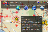 Geospatial Assessment Tool for Operations and Response (GATOR)
Florida's State Emergency Response Team (SERT) uses an interactive map to view RECON reports and other activities along the shore.
Type: Web Mapping Application
Last Modified: September 2, 2011
 Common Operating Picture - For SOAR - Mobile - FINAL
Ohio EMA Watch Office Common Operating Picture
Type: Dashboard
Last Modified: December 1, 2020
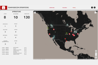 TEAM RUBICON COP
TEAM RUBICON Common Operating Picture (COP) displaying active operations, operations in various stages of planning, weather headlines from NOAA, and media reporting on weather and environmental events provided by our partner Factal.
Type: Web Experience
Last Modified: April 15, 2024
 Operations Response Map
Map showing response activities and resources used in the Operations Response configuration.
Type: Web Map
Last Modified: June 28, 2017


