Understanding the location of Personnel and Assets within Public Safety is a challenging issue, but one well worth spending time trying to manage. GIS is a natural tool to pull this information together – and important because Resource Status information is a fundemental component of any Situational Awareness environment. A solid understanding of where resources are deployed and staged contributes to safety and incident resolution in the most important ways.
CrawlThe first step with limited resources is to adopt GIS Standard Operating Procedures that dictate that you will map incidents and use those maps (and that understanding) to manage resources. Hardcopy mapping displaying the incident allow decision makers insight and can be used (even with Sharpies) to mark up these maps into divisions, branches, and sections – geographic areas – in which to assign and track resources. |
WalkNext, publishing the map to an interactive website (allowing panning and zooming) enables the agency to communicate a representation of the incident that is always official and updated. It solves the problem created by distribution of lots of paper maps that can create confusion with different versions. |
RunWhen you need to track and monitor personnel, vehicles, vessels and aircraft in real-time, you often inherit an ecosystem that is full of many different types of reporting, AVL, GPS, satellite trackers, smart phones, etc. Instead of replacing all of the solutions you encounter a good approach is to utilize a solution that merges all of the existing tracking into one, consolidated feed for you to visualize in the context of GIS. |
| Example: Wenatchee Complex Briefing Map | Example: Incident Information System | Example: Tracking Software |
More Resources
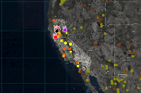
 Cal PreP - Fire Awareness Map
The California Governor’s Office of Emergency Services’ (Cal OES) Cal Prep Fire Situation Awareness app provides an overview of fires, weather conditions and potential impacts in California.
Type: Web Mapping Application
Last Modified: September 8, 2021
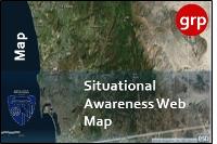 Situational Awareness Web Map of Fire Hazard in San Diego County, USA (Exercise Only)
This is a situational awareness map for fire hazard in San Diego County.
Type: Web Map
Last Modified: August 14, 2016
 Carte des occurrences d'espèces en situation précaire
Carte des occurrences d'espèces en situation précaire
Type: Web Mapping Application
Last Modified: February 7, 2024
 NAPSG Situational Awareness Web Map
NAPSG Situational Awareness Web Map template.
Type: Web Map
Last Modified: April 3, 2024
 2018 June Fires Situation Awareness Map (Public)
2018 June Fires Situation Awareness Map (Public)
Type: Web Map
Last Modified: August 11, 2022
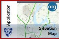 Situation Map for Stafford County
This is a situation map for flooding events and other natural disasters in Stafford County Virginia.
Type: Web Mapping Application
Last Modified: April 23, 2018
 Situational Awareness Map
Map showing hazards, facilities, and infrastructure used in the Situational Awareness Viewer configuration.
Type: Web Map
Last Modified: August 2, 2018
 Situation Map
This is as web map presents a situation map for flooding incidents in Stafford County Virinia
Type: Web Map
Last Modified: April 22, 2018
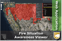
 NAPSG Situational Awareness Viewer
This Situational Awareness Viewer provides an example of how geospatial tools can be configured by technologists to support public safety decision-making. It combines live feeds, incident data, and base data identified as core information.
Type: Web Mapping Application
Last Modified: April 10, 2024
 Carte des occurrences d'espèces en situation précaire
Carte des espèces en situation précaire du Centre de données sur le patrimoine naturel du Québec (CDPNQ)
Type: Web Map
Last Modified: February 7, 2024


