On September 5th, a human-caused fire started near Interstate 5 at Vollmers/Delta exit, north of Lakehead, California (approx. USNG 10T EL 48432 32226). It grew rapidly to the northwest, and California Interagency Incident Management Team 5 assumed command. If you’d like additional official and up-to-date incident details, please see InciWeb.
Shortly after the Delta fire spread to more than 15,000 acres, the Siskiyou Daily News reached out to NAPSG Foundation to find out if there are any resources available that would provide some public situational awareness. We provided links to InciWeb, as well as a web map template that we make available to agencies at no cost. InciWeb then embedded an example web mapping application using the web map template. In the article, Dr. Cassie Hansen, a local Atmospheric Science and GIS Specialist, explains what is on the map and how it should be used. Please note: This is NOT an evacuation map! For evacuation information, please see InciWeb.
As mentioned in our previous post, Core Information Needs for the Public, NAPSG Foundation is prepared to assist agencies with Public Information Maps in advance of human-caused and natural disasters. If you are interested in learning more and interacting with other public safety agencies that use geospatial tools, check out the Resources page and sign up for the upcoming 2018 National Geospatial Preparedness Summit.
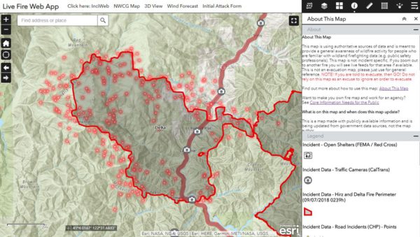
Screenshot from the Delta Fire, September 7th at 10:00 AM local time. See Map Link for updates.


