Accurate damage assessments are critical part of responding to an emergency. Good information about the extent of the damage allows key decision makers to prioritize relief effort, federal reimbursements, and build back after a major event. Mobile GIS allows field workers to access and collect accurate data on a hand held device. The data can be displayed on a map or in an easy to use form with drop down menus. In a connected environment workers can access information from and report data back to an operations center for real time updates as inspections are completed. In an off line environment they can synch the data when they return from the field. Either way, current and accurate information readily available for assessing the extent of damage, managing operations, and developing appropriate response actions.
CrawlWhen an area is devastate by a large-scale event, GIS can be used to support rescue logistics, data collection, status updates and reporting. Paper maps that track locations reported by the field (and often converted from spreadsheets) show exactly where damage has occured and what was in that location before the emergency. |
WalkUsing mobile devices, Public Safety (GPS, Phone apps) can collect data, including photographs of damage and ebris. All this can be downloaded and synchronized with a GIS server. This facilitates a more automated and accurate assessment and provides efficiency for reassignment of emergency crews. It also supports accurate reporting of early damage estimates to all stakeholders and facilitates application for State and Federal Disaster Assistance. |
RunExtending the mobile damage assessment in connected, semi-connected, and disconnected environments is the ultimate goal of using GIS for Damage Assessment. Very often, communications in large-scale disasters is compromised. GIS applications that run on mobile devices, dowload a basemap and incident information while they are at the Incident Command Post or en-route, and can still collect mapping, location, and photo information while disconnected are the key development task in this effort. Once the mobile device re-established connetivity, it synchronizes all of its information with a collaborative geodatabase that is supporting the information and damage assessment. Another key technology note here is that large-scale disasters are a ‘pick up game’, and a good mobile solution is one that supports most modern devices. The technical implication here is that the application is GIS-centric and works either as a disconnected web application (JavaScript/HTML5/CSS3) or a disconnected ‘native’ application (iOS, Android, Windows). This does not constitute an endorsement by NAPSG for any company or product. |
| Example: Search Damage Assessment at ArcGIS Online | Example: ArcGIS Mobile Damage Assessment | Example: Arm360 Damage Assessment |
More Resources
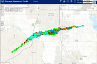
 Tornado Tracks (NWS Damage Assessment Toolkit, filtered for after 12/1/23) - 164fe
This is a feature layer for the NWS Damage Assessment Toolkit. The National Weather Service (NWS) Damage Assessment Toolkit (DAT) has been utilized experimentally to assess damage following tornadoes.
Type: Feature Service
Last Modified: December 11, 2023
 FEMA Historical Geospatial Damage Assessment Database
The Historical Damage Assessment Database is a repository of geospatial damage assessments from past National Disaster events where damage assessments were conducted either using high-resolution imagery or by means of geospatial modeling. The purpose of generating geospatial damage assessments is to provide rapid situational awareness of the number of structures impacted.
Type: Feature Service
Last Modified: June 22, 2021
 Damage Viewer
Welcome to the National Weather Service Damage Assessment Toolkit. Data on this interface is collected during NWS Post-Event Damage Assessments.
Type: Feature Service
Last Modified: May 5, 2021
 Damage Assessment Toolkit Viewer (FC)
NWS Damage Assessment Toolkit (DAT) for webmap for use with the DAT public viewer.
Type: Web Map
Last Modified: May 5, 2021
 Wilkes Barre PA Area Damage Assessment Feature Layer
Wilkes Barre, PA Area Damage Assessment Feature Layer. Commercial buildings, residential buildings, and public facilities are represented. A US National Grid layer for the area is also provided.
Type: Feature Service
Last Modified: July 6, 2018
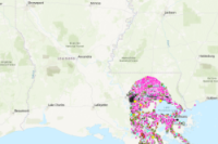 Hurricane Ida Final Damage Assessment
Final version of the visual damage assessment for Hurricane Ida. Data includes crowdsourced analysis data, ML and SME visual inspections. This is the final and authoritative data for the Hurricane Ida Visual Damage Assessment project. However, this is not the final determination of damages by FEMA.
Type: Feature Service
Last Modified: February 9, 2022
 GEMA Damage Assessment Public Editing View
Accounting for damage to residential,commercial, and public infrastructures following an event helps communities in recovery.
Type: Feature Service
Last Modified: June 10, 2021
 Damage Assessment
Accounting for damage to residential and commercial structures following an event helps communities in recovery.
Type: Layer Template
Last Modified: August 25, 2023
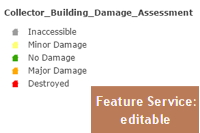 Collector_Building_Damage_Assessment
Template feature service for assessing building damage after a storm event using the Collector app.
Type: Feature Service
Last Modified: August 11, 2022
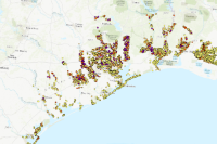
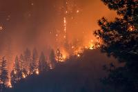 CalFire Damage Assessment 2017
Destroyed structures identified by the CAL FIRE structure damage assessment, following the Sonoma Complex Fires of October 2017 (Tubbs, Nuns, and Pocket Fires). Final update: October 26, 2017.
Type: Feature Service
Last Modified: July 24, 2023


