Help residents discover hazards that exist in their community and obtain information about floods, fires, evacuation routes, shelters, mass care, and government facilities by creating paper maps that can be used when briefing the community and media.
CrawlHelp residents discover hazards that exist in their community and obtain information about evacuation routes, shelters, mass care, and government facilities by creating paper maps that can be used when briefing the community and media. |
WalkProviding an online application of this mapping supports the dissimination of important information 24 hours a day, seven days a week, and typically supplements customer service phone numbers staffed by government and non-government organizations. |
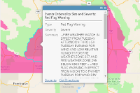
RunExtending the online capability you have created, you can link the data and map symbols to information coming from the field. For example, linking the status of a shelter (open, closed, empty, full, capacity) provides updates to incident managers and the public. |
| Example: Search Evaction at ArcGIS Online | Example: Search Public Warning at ArcGIS Online | Example: USGS Map of Active Floods |
More Resources
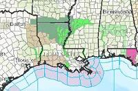 USA Weather Watches and Warnings
A live data feed from the National Weather Service containing official weather warnings, watches, and advisory statements for the United States.
Type: Feature Service
Last Modified: February 16, 2024
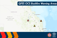 QFES OCS Warnings Areas Public View
QFES Public Warnings over an area updated on demand from the QFES OCS Warnings System.
Type: Feature Service
Last Modified: June 3, 2022
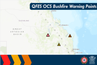 QFES OCS Warnings Points Public View
QFES Public Warnings points updated on demand from the QFES OCS Warnings System.
Type: Feature Service
Last Modified: December 15, 2021
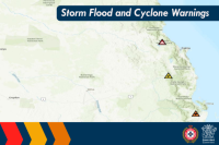 Storm Flood Cyclone Warning Points Public View
Flood Storm and Cyclone Warnings Point Dataset for Public Viewing of Storm Flood Cyclone Events.
Type: Feature Service
Last Modified: December 3, 2023
 Road Closures and Warnings (Public)
Road Closures and Warnings
Type: Feature Service
Last Modified: February 5, 2024
 Teton CO Outdoor Warning Sirens_view
Public view layer of Teton County WY Emergency Management's outdoor warning sirens.
Type: Feature Service
Last Modified: August 25, 2022
 Storm Flood Cyclone Warning Area Public View
Flood Storm and Cyclone Warnings Area Dataset for Public Viewing of Storm Flood Cyclone Events.
Type: Feature Service
Last Modified: March 4, 2024
 Sample - USA Weather Watches and Warnings
This SAMPLE layer of the National Weather Service data feed indicates a variety of weather warnings, watches, and advisory statements.
Type: Feature Service
Last Modified: April 17, 2023
 USA Weather Watches and Warnings
A live data feed from the National Weather Service containing official weather warnings, watches, and advisory statements for the United States.
Type: Feature Service
Last Modified: January 9, 2021
 Weather Warnings (Fire related, National Weather Service)
This is a linked copy of the NWS Weather Watches and Warning layer, filtered just for wildfire-related warnings.
Type: Feature Service
Last Modified: May 7, 2020


