![]()
On June 30th, 2020, the FEMA Response Geospatial Office and NAPSG Foundation hosted the fourth webinar in a series of Emergency Management (EM) Geo Forums: “Technology-Related Guidance & Tools for Hurricane Readiness.” In this forum, participants learned about preparing for future hurricanes in the midst of COVID-19.
Seminar Objectives
In this EM Geo Forum, participants:
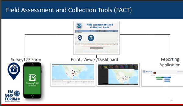
- Learn about FEMA’s Preliminary Damage Assessment (PDA) process.
- Discover tools and resources available to aid jurisdictions in preliminary damage assessments.
- Gain insight into the use of high water marks to improve flood models and damage assessments.
- Learn how FEMA regions work with and support states before, during, and after hurricane landfall.
- Understand how to develop a Geospatial Game Plan to implement across all hazards.
Speakers
This forum featured speakers from the emergency management community who have experience in hurricane preparedness, including PDAs, high water marks, and FEMA Region coordination.
- Paul Doherty – NAPSG Foundation
- Jarrett McLane – FEMA
- Katie Picchione – FEMA
- Alan Johnson – FEMA Region VI
- Adam Barker – FEMA
Seminar Resources
- Link to Recording
- Slide Deck
- Q&A One-Pager
- Hurricane Geospatial Game Plan
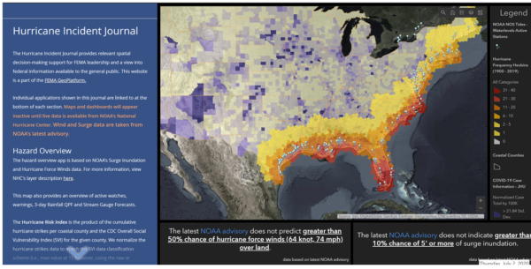
- FEMA’s Hurricane Incident Journal
- FEMA’s Geospatial Resource Center
- FEMA Disaster Community in the GeoPlatform
Background Information
The EM Geo Forum is part of a virtual seminar series featuring best practices and resources to advance emergency management through geospatial capabilities. These seminars promote the integration of innovative technology and solutions in day-to-day operations.